South America Map Pin Flags

$3.00

📩 Digital download

South America Maps and Flag Cards: A Comprehensive Resource for Geography and Social Studies
This comprehensive resource provides a variety of maps and flag cards to help your students learn about the continent of South America. The colored maps show country borders with and without labels, making it easy for students to identify and label the different countries. The outline maps provide a blank slate for students to practice their coloring and labeling skills. The flag cards include 14 different countries with corresponding labels and capital cities.

Rated 5.00 out of 5 based on 1 customer rating
(1 customer review)
Bundle and Get 10% OFF
Collage titled "Brazil: Map Flag Animals Food Landmarks," featuring a Brazil map, native animals, food, and iconic symbols set against the Christ the Redeemer statue backdrop. Montessori Nature Printables
Original price was: $8.00.Current price is: $7.20.
Parts of a Sloth Life Cycle Activities includes worksheets on sloth anatomy, life cycle, habitats, species facts, and a photo of a sloth in a tree—great for fun and engaging classroom or at-home learning. Montessori Nature Printables
Original price was: $7.00.Current price is: $6.30.
A young llama in colorful textiles stands behind printed educational cards from the South America Preschool Activity Pack, which features countries, flags, landmarks, and cultural symbols. Montessori Nature Printables
Original price was: $4.70.Current price is: $4.23.

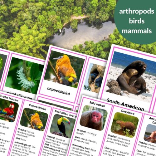
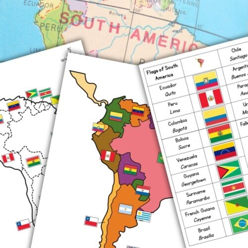
The printable includes:

* Colored maps of South America with and without labels
* Outline maps for coloring and labeling
* Card strips with country labels, flags, and capital cities

Uses:

* Coloring and labeling exercises to teach geography skills
* Flag identification and country recognition
* Map skills and spatial awareness
* Cultural studies and world geography curriculum
* Assessment tools for students’ understanding of South America

Perfect for:

* Teachers of geography, social studies, or world cultures
* Homeschoolers seeking a fun and interactive way to learn about South America
* Educators looking for a comprehensive resource for their students’ geography education

What’s Included:

Colored map of South America that shows country borders – labeled
Colored map of South America that shows country borders – without labels
Colored map of South America that shows country borders with capital city locations marked with a star – without labels
Outline of South America map for coloring
Outline of South America that shows country borders – labeled
Outline of South America that shows country borders and flags
Outline of the political map of South America that shows country borders – without labels
Outline of South America that shows country borders with capital city locations marked with a star – without labels
Card strips with country labels
Card strips with country labels and the corresponding flags and capital cities

**Grade Level:** K-2

**Subject:** Geography, Social Studies

You can read my recommendations on how to prepare and present activities using this printable here.


1 review for South America Map Pin Flags

  1. Rated 5 out of 5

    Rachael J. (verified owner)

    This is exactly what I was looking for and my son has been anxiously waiting to learn more about South American countries (it’s his favorite continent) and to put his flags on his map. He actually helped me to cut out and assemble the flags and they look great!

    Reviewer received an unconditional discount coupon on future purchases

Only logged in customers who have purchased this product may leave a review.

This printable is also included in

Shopping Cart
The South America Map Pin Flags set includes educational sheets with a map, pin flags, country flags, capitals, and a list of countries paired with their capitals and flags. Montessori Nature PrintablesSouth America Map Pin Flags
$3.00